Saturday, 6 February 2016

Iceland 2.28: Hali and Jökulsárlón at Midnight

Our bed for the night was at the Hali Country Hotel, and it is probably the best place we've stayed in the whole of Iceland.  It is situated about 10km east of Jökulsárlón, and incorporates a farmstead where one of the country's most revered authors - Þórbergur Þórðarson - lived.  There is a modern building which is part restaurant and part museum, and its exterior has been imaginatively created to look like a very large shelf of books.


I'd hoped for a decent sunset over Jökulsárlón, as the conditions in the afternoon had been flat light, overhead sun and a clear blue sky.  By the time we'd finished dinner the clouds had descended, unfortunately, but I decided that - being so close to the lagoon - I really had to take the opportunity to go there as the light faded.

Unlike during the day Jökulsárlón's car park was virtually empty, with only a handful of camper vans there.  The lagoon itself was eerily quiet: just me plus some arctic terns, a couple of seals and a flock of barnacle geese for company.  It's a beautiful place at any time of day, but it was absolutely magical to be there as the sun went down.  I can only imagine what it's like in winter with the aurora borealis playing overhead.


There was a golden patch in the sky for a while, but not the spectacular sunset I had hoped for.  Things improved after the sun had dipped behind the mountains, however, as the lighting became much more even and I was able to take full advantage of the "blue hour".


I was fortunate to be at Jökulsárlón at the turn of the high tide, meaning that the river flow which takes the bergs out to sea was virtually non-existent.  Even so, with exposures in the 30 seconds to 2 minutes range, it was inevitable that there would be some movement visible.


One particular berg caught my eye when I was at the water's edge, so I moved onto higher ground in order to get a better look.  It was being used as a roost by dozens of arctic terns; and, more importantly, it was big enough not to move during the long exposure.  It was just after midnight when I took these shots, but there was still enough light in the sky to see what I was doing.  Just.


By 1am I was getting cold and tired, but decided to go down onto the beach for half an hour before heading off to bed.  The light had dropped sufficiently that I needed a torch to find my way around, and the images of the beach bergs were taken in almost complete darkness.  At this point, cold but happy, I went back to the hotel, trying very hard not to wake Harriet up in the process.


True landscape photographers are clearly made of sterner stuff than me, but it was still a wonderful and peaceful experience which I shall remember for a very long time.

Thursday, 4 February 2016

Iceland 2.27: Skeiðarársandur and Skaftafell

Having spent almost three solid days in the highlands, driving on rough roads and fording endless rivers, it was a bit of a shock to be back in "civilisation".  It was necessary to face reality, if only to fill the car with fuel and grab a bite to eat, so we stopped at a service station on the outskirts of Kirkjubæjarklaustur.  The place was absolutely heaving, though, so we went on to a much smaller kaffi we knew in the centre of the town.


Suitably fortified we prepared to cross Skeiðarársandur: a 35km stretch of featureless black sand, which is the result of a series of Jökulhlaup events.  A Jökulhlaup is triggered when the "dam" holding back the lake at the foot of a glacier is breached, often as the result of volcanic activity under the ice.  The resulting torrent then washes down the valley, taking all the glacier debris with it and destroying anything in its path.  Huge sand "estuaries" are created as a result, and Skeiðarársandur is the largest in Iceland.  Half way across there are the remains of a bridge which was destroyed during a Jökulhlaup in 1996.  It now stands as a memorial, demonstrating the unimaginable power of these events.


The view from the middle of the sandur was better than we'd ever seen it, with the Vatnajökull ice cap and its glaciers clearly visible.


The headquarters of the Vatnajökull national park are at Skaftafell, very close to the Skaftafellsjökull glacier.  Since it was such a beautiful afternoon we decided to walk to the glacier, taking in the scenery and plant life as we went.


I never cease to be blown away by the majesty of a glacier, and as we approached we could see it looming in the distance.  The glacier was clearly retreating too, as we had to walk across a wide expanse of terminal moraine before we came to the ice itself.


On a lovely summer's day, with beautiful clear scenery, it's difficult to imagine quite how dangerous glaciers can be.  Those attempting glacier walks were warned in no uncertain terms about the equipment needed and the perils of ice caves and crevasses.  We weren't prepared for such activities (and, anyway, we'd been on the go all day) so decided to head slowly back to the car and aim for Hali, a few kilometers east of Jökulsárlón, which would be our base for the night.


Wednesday, 3 February 2016

Iceland 2.26: Eldgjá

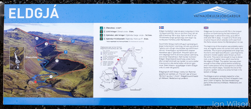
Eldgjá is an enormous volcanic fissure, formed in the year 934, which is 8km long, 400m wide and 150m deep.  It is part of a much larger eruptive fissure - over 75km long - which extends all the way to the Katla volcano.  Eldgjá itself is part of the Vatnajökull national park, and as such it is looked after by resident park rangers during the summer months.  There were two there when we visited, and they told us it had rained every day since they arrived.


It was raining on the day we visited too, but there was a break in the clouds so we decided to walk up the valley to have a look at the waterfall.  Before doing so we investigated one of the many volcanic vents in the area, which turned out to be pretty deep with snow at the bottom.


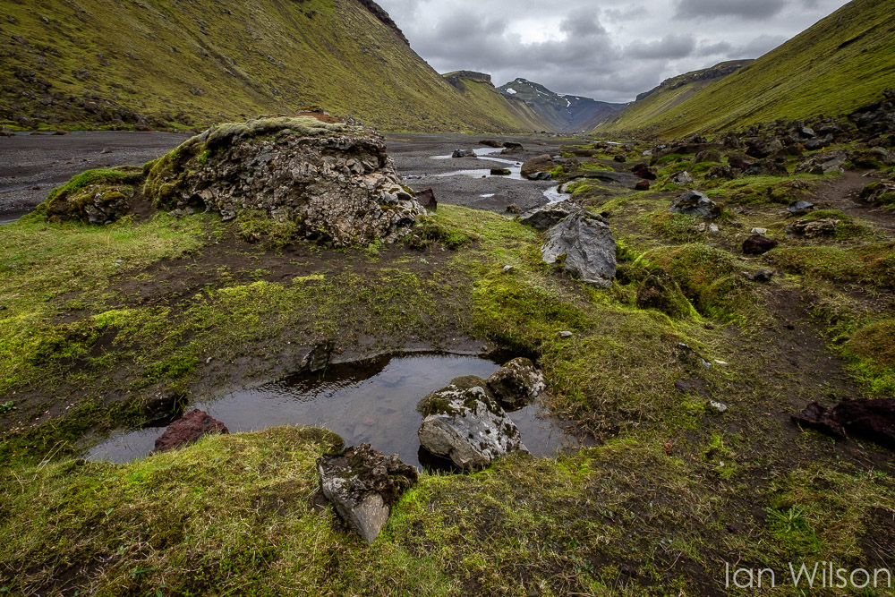
The valley started off fairly wide, but with very steep sides.  It began to narrow as we approached the waterfall, and there was evidence of volcanic activity absolutely everywhere.  This included the same bright red "house brick" formation we had observed when visiting Krafla.


Eventually we reached the waterfall, which was well worth the effort expended in getting there.  Some hardy souls decided to cross the river and climb up the waterfall itself, but since we still had quite a distance to drive we decided to stay on the valley floor.  The views were still pretty good, and enhanced by the dark, brooding sky.


I had just enough time to take a handful of "big stopper" shots, which had the inevitable effect of smoothing both the water and the sky.  My feeling is that the filter has actually removed some of the menace from the location, so on the whole I prefer the unfiltered shots in this instance.  I'm sure other people will disagree, however.


It was a very long, hard and bumpy drive across as we headed towards the coast, and there were far more rivers to ford than we'd met when crossing the Sprengisandur.  Eventually, as we descended off the highlands, we could see that it was very hazy in the distance - the effect of a sandstorm over the Skeiðarársandur.  At Grof we found a small church with a graveyard, and it was mandatory to stop and have a look.  There was no time to go inside, unfortunately.


By now we had hit "brown" roads (normal, gravel tracks which can be used by all car types), which showed that we were getting close to civilisation.  It wasn't long before we were driving on "red" roads (with the luxury of tarmac), and very soon we had joined route 1 just west of Kirkjubæjarklaustur.  That was the end of our serious highland driving experience, and it was something I wouldn't have missed for the world.